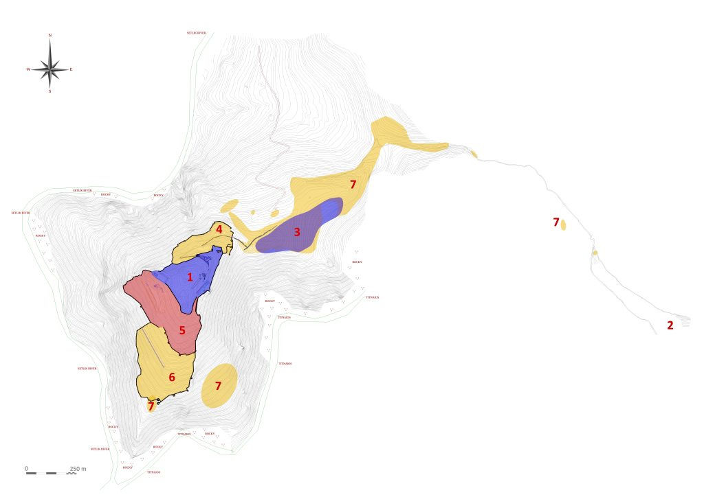
It is known that the settlement areas expanded on an enormous scale with the intense development programs carried out in the city during the Hellenistic Period. On the other hand, the political uncertainties experienced during the Diadokhoi Period and the conflicts it brought along created an extremely unsafe environment for the region. For these reasons, defense lines were built on a single route on the northern slope of the city, and on two separate routes gradually on the southern and southwestern slopes. Analogical evaluation of the planning and workmanship on the walls with the examples of Assos, Pergamon, Herakleia and Theangela indicates the dates for their construction between the first half of the 3rd century BC and the middle of the 2nd century BC. Therefore, it is known that at least in the second half of the 2nd century BC, the total width of the city, bounded by the defense lines, reached 23.2 hectares.
Two main political processes stand out in Aigai, which required the construction of Hellenistic defense lines. One of them is the conflicts between the Pergamon and Seleucid Kingdoms, starting with the short-term occupation of the region in 223 BC by the Seleucid General Akhaios and extending to the Magnesia War in 190 BC. After this turbulent period, it is suggested that the defenses in Pergamon were strengthened between 179-174 BC during the reign of Eumenes II without a war. Perhaps the walls in Aigai were also expanded or strengthened in the same years. Another important development was the devastating destruction of Aigai, like Methymna, Kyme and Herakleia, during the war between Attalos II and Bithynia King Prusias II in 156-154 BC. However, in 154 BC Prusias was forced to pay a hundred talents as compensation to the cities he had damaged. Expensive monumental public structures such as the bouleuterion, agora building, agora west stoa, theater and gymnasion, and the stoa of the sanctuary of Athena in Aigai were built on exactly these dates, just after the middle of the 2nd century BC. Probably during the same period, repairs, reinforcements or additions must have been made on the Hellenistic walls that bordered the city.
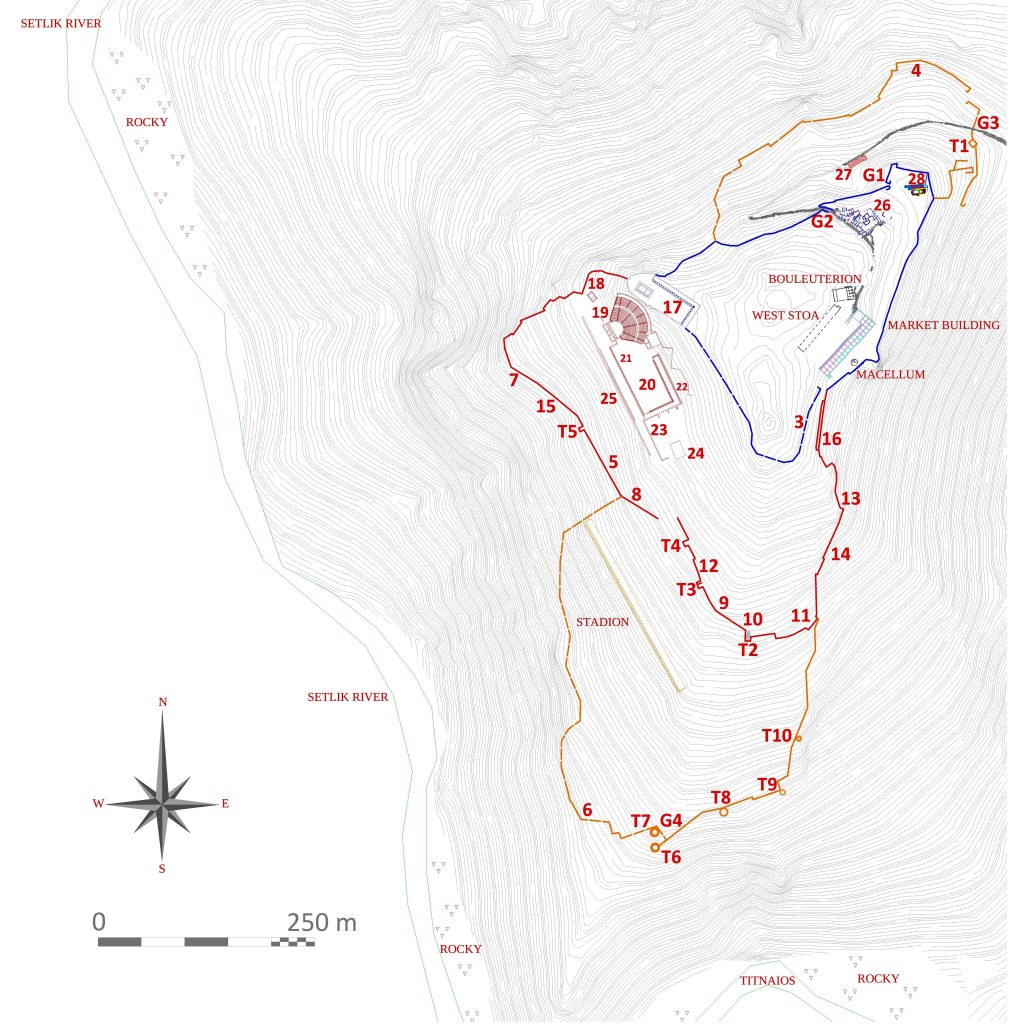
The length of the Hellenistic wall on the northern slope, which can be followed today, is about 500 m, and its length in ancient times is about 630 m. it was as much. The area bounded by the walls, the thickness of which varies in the range of 1-1.80 m, outside the acropolis is approximately 3 hectares.
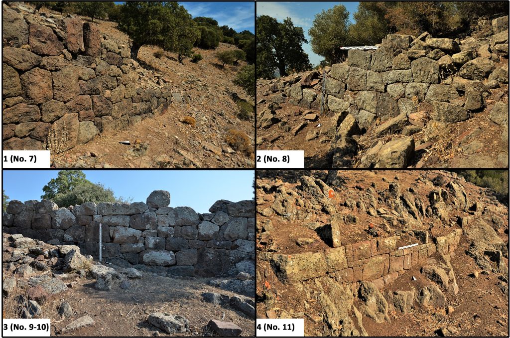
The city wall gate is on the eastern wing, where the ancient road from the necropolis to the city reaches the city wall. Unlike the other lapped gates in the city, the gate probably has a plan with a double tower and a courtyard, or a single tower and a cantilevered fortification wall. The rectangular tower adjacent to the southeast supports this idea. The tower, whose northern façade slopes towards the south, has a wefted-isodomic row weave made of rectangular cut stone blocks. The towers that cut the city wall, a planning that became widespread with the Hellenistic Period, protrude widely towards the inside of the city wall, unlike the examples in Pergamon, Piraeus, Side, Gortis and Miletos. The example in Aigai is similar to the examples of Perge, Eleutherai and Dura-Europos in this respect.
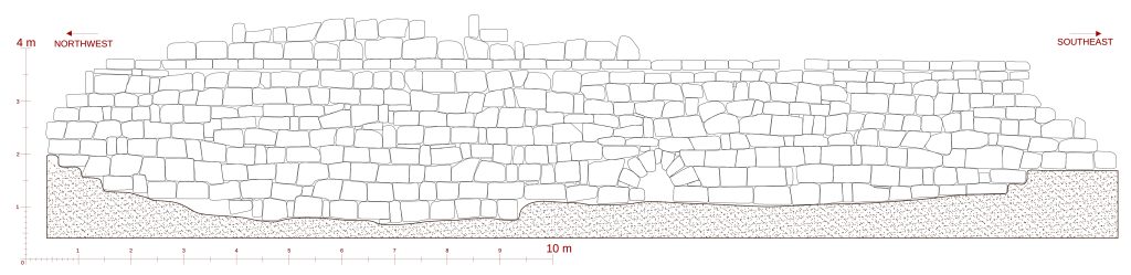
The line of the Hellenistic diateikhisma wall in the south, which can be followed today, is 996 m, and its length in antiquity is approximately 1080 m. Its thickness is 1.30-2.20 m. The area bounded by the walls varying between Various masonry techniques are striking at different points of the wall line.
Diateikhisma wall, unlike the early period acropolis walls, is supported by four bastions that protrude in the form of a quadrangle, especially in the south and west parts where the slope is low. In the southeast and northwest parts, where the slope increases, the need for a bastion or tower was met with fortification walls planned in the form of cantilevers and sawtooth.
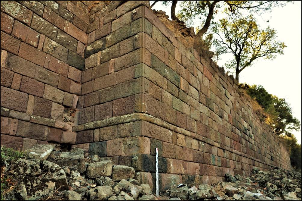
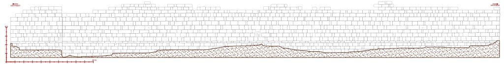
The outer width of the bastions varies between 29-55 m2. Of these structures with different masonry, especially the B2 example is partially better preserved. In the core part of the building, which consists of two parts, a wefted-isodomic row weave was used in the overlapping technique, and a pseudo-isodomic row weave was used in the buttress section adjacent to the northwest. Due to the zipper overlapping technique on the northwest corner of the buttress, an aesthetic chamfering process has been applied on this corner. Thanks to the other examples in Aigai, Pergamon and Assos, which are similar in terms of beveling application and masonry techniques, the construction date of the bastion in question is 2-1 BC. centuries recommended.
The eastern and western ends of the Hellenistic fortifications forming the outer defense line on the southern slope were based on diateikhisma. With the addition of the outer wall in the south, the areas covered by the acropolis and diateikhisma are the upper city; It is felt that the areas covered by the outer walls in the north and south have gained the concept of the lower city. The route of the southern outer wall, which can be followed today, is 430 m, and its length in antiquity is approximately 865 m. Its thickness is 1-2.10 m. The area surrounded by the walls varying between 7.3 hectares. The fortification walls, which are quite destroyed, were built with cut block stones in an isodomic rowing technique. In the completely destroyed parts, bedrock beds that have been worked for the establishment of the wall foundations can be traced.

Five towers with a circular plan were built as supporting elements on the aforementioned defense line. The two towers, K2 and K3, with a diameter of 9.65 m outside and 8.50 m inside, support an arched gate at the southern end of the south slope. It is thought that the lap door on the northwest-southeast axis may have had a double-towered courtyard plan. Wefted-isodomic row weave was used in the overlapping technique of cut stone blocks in the towers. In parallel with the city plan, which expanded with the development programs in the Hellenistic period, the necropolis areas in the south and north also expanded and reached the outer defense walls.
The Doric architectural order, which was dominantly preferred with the positioning of public and religious buildings in the upper city within the framework of the Hellenistic Period reconstruction programs in Aigai, are concrete reflections of a common architectural understanding and city design implemented under the hegemony of Pergamon in the 2nd century BC. The bouleuterion, the agora building and the square where the west stoa of the agora is located were redesigned during the Attalos II period and the surviving forms of these structures were built in this period. Thanks to the Bouleuterion, whose excavations were completed, it is known that an early assembly existed here between the second half of the 4th century BC and the beginning of the 2nd century BC. In the middle of the 2nd century BC, a larger sized parliament was built on top of the early council. The location of the Agora building, the agora west stoa and the Bouleuterion, and the axis boat between the agora stoa and the west stoa, are quite similar to the planning in Assos in the same century.
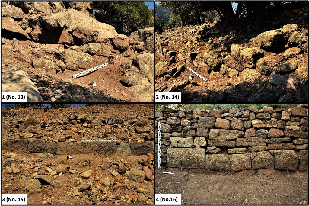
The preserved length of the upper terrace wall (No.13), which is thought to extend from the south end of the gymnasion palaestra and continues to the northwest of the theater, to the Temple of Demeter-Kore due to its remains (No.13), is 88.80 m and its height is 3.40 m. 85 cm. In the northwestern part of the wall, polygonal knitting technique with straight edges was used. It is known that this technique, which is different from the Lesbos type polygonal knitting, was used intensively between the end of the 3rd century BC and the last quarter of the 2nd century BC, thanks to the epigraphic evidenced examples in Western Anatolia and especially in the Olba territorium. The southeastern part of the wall, which was damaged, was repaired using a wefted-isodomic row weave using ashlar block stones (mid 2nd century BC?). In the northwest part, three “Thurides Toskai”, namely crenellation holes, located at different elevations, are probably intended to keep water and moisture damage away from the structure. A second wall extending on the same axis, adjacent to the eastern side of the terrace wall, creates a peristasis of 80 cm. Its preserved length is 64.25 m., its thickness is 35-50 cm. This support wall, which is between Approximately 40 cm. The two walls are connected to each other thanks to the scarves formed by overlapping three thick stones.
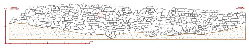
The gymnasion terrace wall, adjacent to the southeast of the upper terrace wall, is 2.5 m. It extends to the south by protruding in two steps in length. At the same time, the length of the wall holding the terrace to the east is 56.4 m, and its preserved height is 5.96 m. It has a wefted-isodomic row weave in the overlapping technique made of cut stone blocks. On the northwest corner of the wall, chamfering was applied as the 2nd century BC Aigai tradition. In addition, an isodomic sequential belt extends at the lower level of the building.
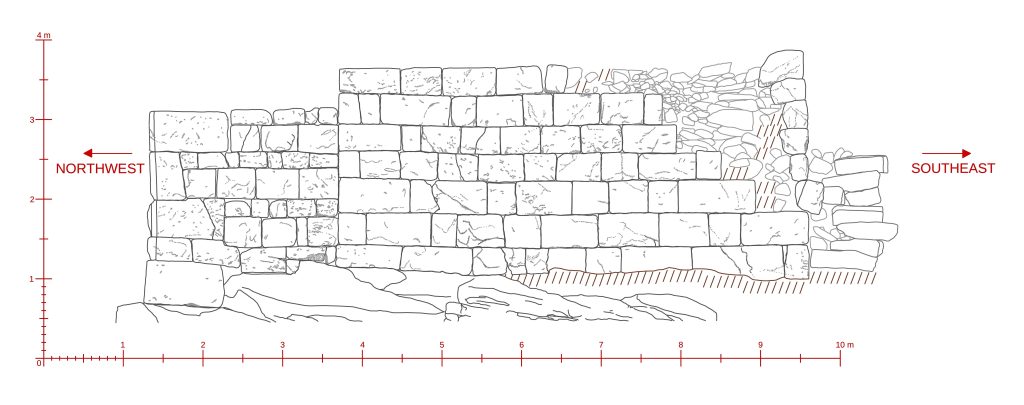
9.65 m west of the upper terrace wall that supports the gymnasium and theater plain, and on the lower levels, a preserved lower terrace wall (No. 11) with a length of 177.41 m, a height of 3.90 m and a thickness of 1.10 m extends. The original weave of the wall, which extends on the same axis with the upper terrace wall and shows different repair phases, is preserved up to a height of 1.50 m, and has a wefted-isodomic row of trapezoidal stones in the overlapping technique. An isodomic belt extends at the 3.11 m high point. The drainage hole under the wall is designed in the barrel vault technique. A second support wall (No. 12) extends on the same axis just behind the wall. The wall, which has a complex row of logaden mesh made of coarse crushed stones, both reduces the static load for the lower terrace wall in front of it and acts as a wall mattress thanks to the peristasis it creates.